Collision avoidence (AIS, RADAR) - Flingtime
Main menu:
Collision avoidence (AIS, RADAR)
This was our first significant collision avoidence situation. After an early, re-dawn, start we had just finished a breakfast of BBQ bacon & eggs and were heading north past the very busy Gladstone Harbour area, we had decided to simply stay out to sea just beyond the 'parking lots' and set course direct for Cape Capricorn on the north of Curtis Island.
The next four screen shots show the course overview (red waypoints), AIS without Radar, AIS with Radar overlay, and the situation as we were about halfway past the southern anchorage area.

")
")

A threat was identified via the AIS over 10miles away to the north.
In the screen shot its speed had reduced somewhat to around 10kts but it was very large vessel.
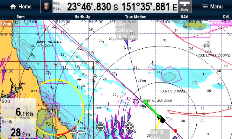
AIS indicated that collision was almost a certainty. Also the bow waves from such a large vessel were huge and the skipper decided to give it at least a 1 mile miss.
He called Gladstone Port Control via VHF (Ch13) and advised intention to change course towards the east.
Flingtime has a Class B AIS which does not transmit data; receive only. The incoming vessel probably saw us on Radar as the reflector was properly mounted at the time.
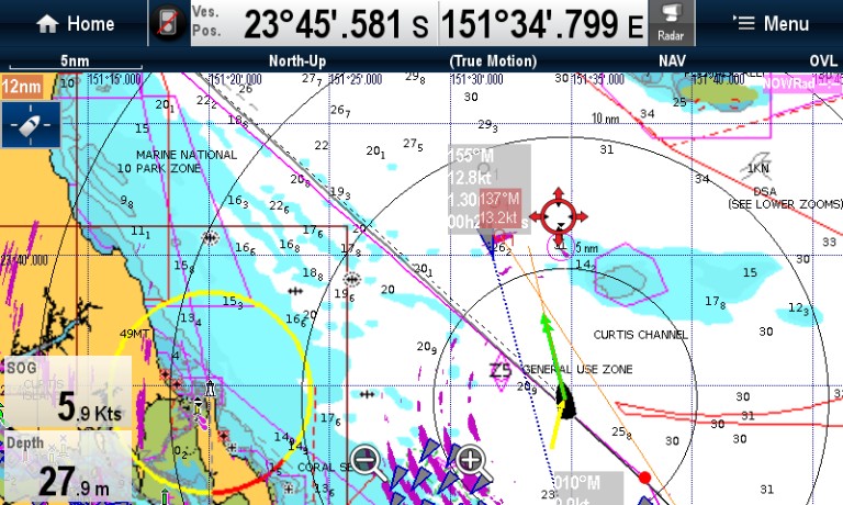
The next screen shot shows paths after the course change.
Interestingly, the vessel increased speed from 9.6 to 12.8 knots after we had advised that we were clearing out of the way.
The once the vessel was an acquired MARPA target, the AIA and Radar course projections were not identical, however we were in between the two lines.
Note: (System software version as available in early 2013) To determine the name of the vessel it is necessary to use the i7 instrument AIS page and select the specific target for more detailed information. The e7 AIS tracking display just provides the most important pilotage data.
To acquire the MARPA target, use the Radar display on the e7, set the cursor over the target and select it for target acquisition. Overall the process is a bit cumbersome.See later notes for i7 AIS page image.
Course towards Cape Capricorn resumed. We were relieved and happy with the actions taken.

Surprise, surprise!Soon after handling the first potential collision, we picked up another large and much faster (19.2 knot) threat, just 5 miles away. The trouble with this one was that it apeared to be headed either to the main channel or to the northern anchorage area.
Avoidence required full throttle motor sailing and a quick decision (no vector calculations!) was made to set the course was at right angles to the projected AIA path as the best action to take. This may have been the shortest way out although it required crossing the bows of the incoming vessel. Once again we wanted a good distance for the wash to settle down.
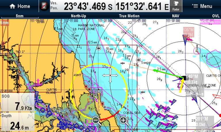
Screen shot of the avoidence path.
This one series of events definitively proved the worth of the AIS installation