Day 9: Pancake Creek – Hummocky Island (via Cape Capricorn) - Flingtime
Main menu:
- Background
- Day Zero, Day-1: Jacob's Well - Wellington Point
- Day2: Wellington Point - Pumicestone Passage (Bribie Island-South)
- Day-3: Pumicestone Passage - Mooloolaba
- Day 4: Mooloolaba - Double Island Point
- Day 5: Double Island Point – Garry’s Anchorage, Gt.( Sandy Straights)
- Day 6: Garry’s Anchorage – Urangan
- Day 7: Urangan – Burnett Heads (Bundaberg)
- Day 8: Burnett Heads – Pancake Creek
- Day 9: Pancake Creek – Hummocky Island (via Cape Capricorn)
- Day 10: Hummocky Island – Rosslyn Bay (via Lisa Jane Shoals) – Great Keppel Island
- Day 11,12: Great Keppel Island (Leeke’s Beach)
- Day 13: Great Keppel Island – Rosslyn Bay
- Day 14: Rosslyn Bay – Pearl Bay
- Days 15,16,17 - Pearl Bay....
- Day 18: Pearl Bay – Hexham Island
- Day 19: Hexham Island – Curlew Island
- Day 20: Curlew Island - Mackay
- Day 21: Mackay
- Day 22: Mackay – Goldsmith Is.
- Day 23: Goldsmith Is. – Hamilton Is. - Sawmill Bay
- Day 24: Sawmill Bay - Blue Perl Bay – Hook Is., Stonehaven Bay
- Day 25: Stonehaven Bay - Nara Inlet
- Day 26: Nara Inlet –via Whitsunday Passage/Molle Group – Hamilton Is
- Day 27: Hamilton Is – Shag Islet (Passage Is.) in Gloucester Passage
- Day 28: Gloucester Passage - Cape Upstart
- Day 29: Cape Upstart - Townsville
- Day 30: Townsville – Horseshoe Bay (Magnetic Is.)
- Day 31: Horseshoe Bay (Magnetic Is.) at anchor
- Day 32: Magnetic Is. – Orpheus Is. (Palm Group)
- Day 33: Orpheus Is. – Dunk Is.
- Day 34: Dunk Is.- Etty Bay – Johnstone River (Innisfail)
- Day 35: Innisfail – Fitzroy Is.
- Day 36: Fitzroy Is. – Vlasoff Cay – Michaelmas Cay
- Day 37: Michaelmas Cay – Yorkey’s Knob (Half Moon Bay Marina)
Day 9: Pancake Creek – Hummocky Island (via Cape Capricorn)
Once again we had a long leg ahead of us so we were off to an early start. After a good 5 1/2 hrs of sleep we woke at 03:30. Navigatrix decided that we really ought to arrive at Hummocky Island before dark and we had Gladsrone traffic to contend with. Today's journal is a bit more detailed as there was a lot of interest going on.
04:40 we departed about 1 1/2 hours after high tide. The weather reports were not particularly consistent and indicated reasonable winds but ranging from NE to NW with rain developing.05:30 we were motor sailing with TWS 4.6kt WSW, SOG 6.5kts.
06:15 another glorious sunrise06:35 we kept outside the Gladstone Port anchorage boundary and noted that as we had a 5 degree heading to course variation. 07:20 Navigatrix sorted out log on details between Gladstone VMR and Round Hill VMR a we commited to Hummocky as our destination.
Yet another stunning sunrise. Exceptional. These pictures were not 'photo shopped', just a fill-in flash with the sun rising in the background.
Shortly after this, our skipper confirmed from the AIS and radar that our course was presently a collision course with an large vessel approaching Gladstone at 20 knots. It was the Stenia Colossus but it was still a long way out and barely visible on the horizon. It appeared to be heading towards the southern 'parking lot'.
No doubt Gladstone Port control was aware of us and watching to see what happens so the skipper call them up on the radio and advised our planned course change.
08:00 the Stenia Colossus passed us to port so we changed course to cross about 1NM behind it.
08:05 Hard on the heels of this manoeuvre was a second potential collision with Fairpartner steaming in at 22 knots. However this one was heading for the northern parking lot, as were we. Skipper did some calculations and changed course to safely cross in front of it at right angles to its present course. We gunned our little motor and were making SOG of 6.3 knots.
08:20 and our present position put us at least 1NM out of harms way so we resumed our planned course.
08:30 camly motor sailing (pottering along) at 4.6 knots with main & jib TWS 7 knots from the south.
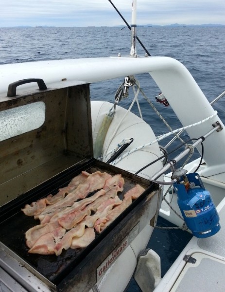
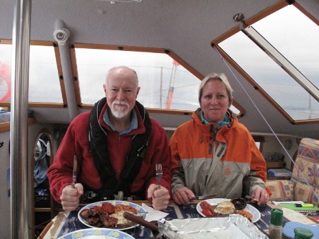
We were all ravenous after all of the excitement so the skipper cooked a hearty breakfast of bacon, eggs, portobello mushrooms, roma tomatoes, baked beans, burger rye toast and plunger coffee. Yum.
Breakfast for the starving crew
10:05 the SSW wind had picked up to11 knots so we lifted the motor, left the main hoisted, furled the jib, and let the spinnaker loose for a SOG of 4.5 knots.
11:50 the breeze was fading so we doused the spinnaker and continued with motor sailing.
12:10 wind shifted to SSE at 6-7 knots
13:25 rounded Cape Capricorn and were very impressed by the magnificant rocks with the lighthouse and two attendent houses perched on top; we all took lots of photos of it.
The wind had faded so we lowered the main sail and motored along to check out Yellow Patch which is still on out sailing bucket list. Despite our shallow draft of 750mm, our chances of finding a way in were quite low as it was LW+1 hour. We crawled around the sand bars and chatted with a small power boat who checked out a possible path. He eventually found one but it was not right up next to the beautiful yellow-orange sand hill where a few boats were quietly anchored. Oh well ... next time; we headed off towards Hummocky.
15:35 Arrived at the western side of Hummocky Is at HW-3.5 hours, did the tidal range calculations and dropped 25 metres of chain. the wind was SE at 5-6 knots and the cove was picturesque with a good sandy bottom.
16:05 First mate phoned VMR Gladstone and CG Keppel Sands to sort out the log-off and next day's planned leg.
The latest weather report predicted a wind change to the NNW and this appeared to be happening so we moved around to the small anchorage on the east side while we still had good light. The skipper saved waypoints between the anchorages just in case.
The sandy bottom was visible in a few patches so we chose one fairly close in and anchored there on 30metres of chain plus the bridle length.
19:00 about. Michael caught two Stripies so we BBQ'd them for dinner with ratatouille.
Then the wind shifted back to SW, it started to rain and we were starting to rock and roll.
We set a series of alarms; Depth shallow @ 2 metres, deep @ 6 metres, and two lot of GPS anchor drag alarms. In this function only, the main plotter only took feet so it was set to 275' as (30+10)*2 metres works out to be around 240'. The emergency handheld GPS, a Garmin was set to 90meters.
The BoM weather report still predicted a strong night time wind shift to the NNW; more or less the opposite to what we were experiencing. Buoy Weather had winds as SW at 8-11 knots.
We hit the sack and slept fitfully.
